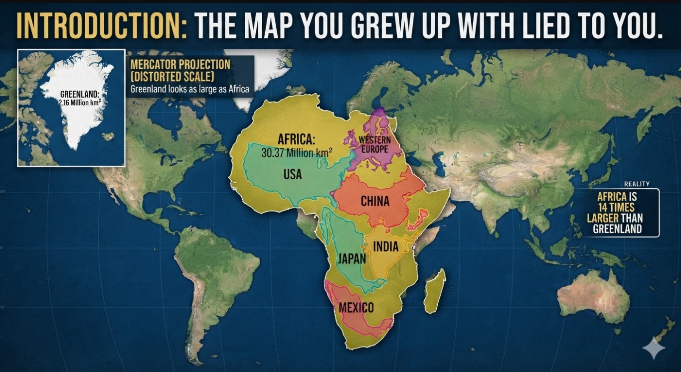
✨ Introduction: The Map You Grew Up With Lied to You
Most of us grew up with the Mercator projection—the map that made Greenland look as big as Africa. In reality, Africa is 14 times larger than Greenland, covering 30.37 million km². You could fit the U.S., China, India, Japan, Mexico, and most of Western Europe inside Africa and still have space left.
For centuries, maps shrank Africa while inflating Europe and North America. Now, a global movement is correcting this distortion, and the ripple effects are profound.
📜 When Did This Start? A 500-Year-Old Distortion Finally Gets Called Out
- Mercator Problem (1569–Present): Designed for navigation, it distorted land sizes—shrinking Africa and enlarging Europe.
- Slow Awakening (1970s–2000s):
- 1973: Arno Peters introduced the Gall-Peters projection.
- 2001: Kai Krause’s viral “Africa Size Comparison” graphic shocked the world.
- 2010s: TheTrueSize.com let users drag countries to reveal distortions.
- Tipping Point (2017–Present):
- 2017: Boston schools adopted Gall-Peters maps.
- 2018–2020: National Geographic switched to Winkel Tripel.
- 2022–2023: African Union pushed equal-area maps globally.
- 2023–2025: Schools and tech platforms worldwide began mandating accurate projections.
🗺️ What Does the “Resizing” Mean?
It’s not about redrawing borders—it’s about cartographic correction.
- Mercator: Great for navigation, but distorts size.
- Gall-Peters: Accurate area, odd shapes.
- Winkel Tripel: Balanced compromise.
- Equal Earth (2018): True scale + visually pleasing.
💡 Why It Matters
Psychological & Cultural Impact
Maps shape perception. Shrinking Africa reinforced marginalization. Correcting it is cognitive justice.
Decolonizing Knowledge
Mercator maps are seen as colonial artifacts. Resizing is part of decolonizing education and media.
Geopolitical Reframing
A true-sized Africa commands respect in negotiations, climate talks, and global affairs.
💰 Economic Impact
- Investor Perception: Africa’s GDP (2024) is $2.96 trillion. The African Continental Free Trade Area is the largest in the world.
- Resources & Climate: Africa holds 30% of mineral reserves, 60% of uncultivated arable land, and the Congo Basin rainforest.
- Tourism & Branding: Campaigns now highlight Africa’s vastness—from the Sahara to the Serengeti.
🎓 Impact on Schools & Education
- Global Classroom Revolution: Schools in the U.S., U.K., Germany, France, South Africa, Kenya, and Nigeria now teach map bias.
- African Students: Gain pride and belonging seeing Africa’s true scale.
- Non-African Students: Confront distortions and learn about bias in data and media.
🌐 The Bigger Picture
- Media: BBC, Al Jazeera, and African outlets adopt accurate maps.
- Technology & AI: Mapping algorithms recalibrated.
- International Organizations: UN, World Bank, IMF pressured to adopt equal-area maps.
- Art & Culture: Murals, films, and installations challenge cartographic colonialism.
🌋 Geological Twist
Africa is physically splitting via the East African Rift System. In 5–10 million years, a new ocean will form, and the Horn of Africa will become a new continent.
🏁 Conclusion: A Map Is Never Just a Map
The resizing of Africa is more than technical—it’s cultural, educational, economic, and decolonial.
“Africa was never small. The map was.”
🔖 Hashtags
#TrueSizeOfAfrica #DecolonizeTheMap #CartographicJustice #AfricaRising #EducationReform